Overview of Realtor Drone Photography
Realtor drone photography has emerged as a transformative tool in the real estate industry, particularly within dynamic markets like Miami. This innovative approach involves capturing high-resolution aerial images and video footage of properties and their surroundings using unmanned aerial vehicles (UAVs). These aerial visuals provide prospective buyers with a comprehensive perspective of a property’s layout, exterior features, and neighborhood context, which traditional ground-based photography cannot easily convey.
The utilization of drone technology allows real estate professionals to showcase unique selling points such as expansive lawns, waterfront access, proximity to local amenities, and spectacular vistas that define Miami’s luxurious properties. As the housing market becomes increasingly competitive, high-quality drone imagery has become a crucial component of compelling real estate marketing strategies, helping listings stand out in a crowded marketplace.
Realtor drone photography supports virtual tours and online listings by offering engaging and detailed visual content that enhances the overall presentation. With advancements in camera stabilization, high-definition resolutions, and flight automation, drone photography today not only captures aesthetic beauty but also delivers precise, panoramic views that enable potential buyers to virtually explore properties as if they were physically present on-site.
In Miami, where waterfront and high-rise condominiums dominate the real estate scene, drone photography provides an unparalleled vantage point that highlights the property’s surroundings, overlooking ocean views, cityscapes, and landscaping details. Incorporating aerial imagery into property listings has become a standard practice to craft a powerful visual narrative, attract more interest, and facilitate faster sales.
By integrating drone photography into their marketing toolkit, Miami real estate professionals can better illustrate property features, offer immersive viewing experiences, and create compelling visual stories that resonate with today’s digital-savvy buyers. This synergy of aerial technology and real estate marketing marks a significant evolution, elevating how properties are branded and showcased in Miami’s vibrant marketplace.
Legal and Regulatory Considerations
When integrating drone photography into real estate marketing, understanding the frameworks governing aerial filming is essential for maintaining professionalism and ensuring compliance with regional standards. In Miami, this involves adhering to established protocols that govern airspace usage, privacy, and operational safety. Real estate professionals often collaborate with certified drone operators who are well-versed in regulations, ensuring that flights are conducted within approved zones and altitudes. It is important for agents to verify that their chosen drone service providers follow the latest guidelines issued by relevant authorities. This includes securing necessary flight permissions, especially when capturing images over private property or in densely populated areas. By working with experienced providers who prioritize safety and regulation compliance, realtors can avoid potential legal hurdles and focus on producing high-quality visual content. Furthermore, privacy considerations are paramount in densely populated neighborhoods or waterfront communities like Miami. Ensuring that drone operations respect residents' privacy rights involves strategic planning of flight paths and exclusion zones. Transparent communication with property owners and neighbors about drone activities can foster trust and facilitate smooth cooperation. In addition to operational rules, maintaining comprehensive documentation of drone flights, including permits and flight logs, enhances accountability and professionalism. This proactive approach not only aligns with best industry practices but also supports the reputation of real estate agents aiming to deliver ethically produced visual content. In summary, integrating drone photography into Miami's real estate marketing efforts necessitates a thorough understanding of local regulations, adherence to safety protocols, and respectful privacy management. Partnering with qualified drone operators who prioritize regulatory compliance ensures that aerial imaging adds value to property listings while safeguarding all parties involved.
Equipment and Technology Used in Realtor Drone Photography
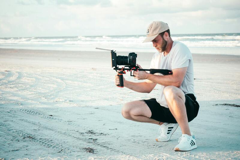
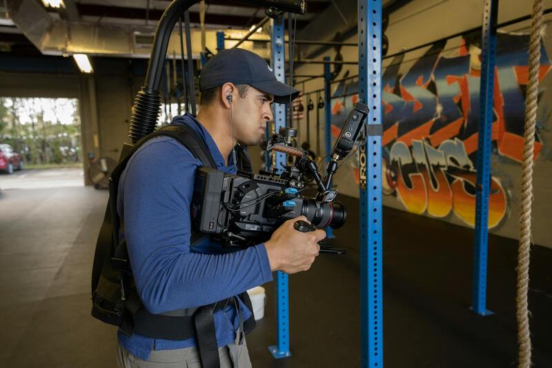
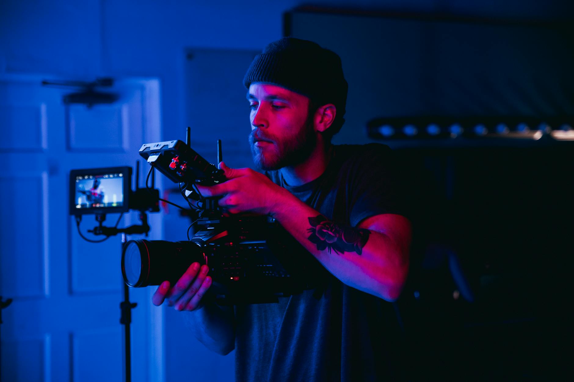
The foundation of high-quality realtor drone photography lies in utilizing advanced and reliable equipment. Modern drone systems are equipped with sophisticated stabilization technology, high-resolution cameras, and adaptive flight controls that enable capturing stunning visuals from multiple angles and altitudes. When selecting drone hardware, professionals prioritize models with capabilities such as 4K or higher video resolution, high dynamic range imaging, and extended flight times to ensure comprehensive coverage of properties.
In addition to the drone itself, the integration of supplementary accessories can significantly enhance the quality of aerial content. Gimbals are essential for stabilizing cameras mid-flight, resulting in smooth footage devoid of jitters or vibrations. External lenses, such as wide-angle or fisheye options, allow for capturing expansive views of property exteriors, landscapes, and surrounding neighborhoods.
Operational software plays a crucial role in executing precise flight paths and capturing consistently well-composed imagery. These flight planning tools enable predetermined routes that maximize coverage while maintaining safety margins, especially in complex environments like densely built Miami neighborhoods. Advanced flight control systems incorporate GPS stabilization, obstacle avoidance, and automatic return-to-home functions, which streamline operations and reduce risks.
Furthermore, data transmission technology allows for real-time monitoring of flight status and footage quality. High-speed video transmission systems ensure that operators can make immediate adjustments during flights, allowing for rapid response to changing environmental conditions or compositional requirements.
In terms of post-flight processing, high-quality editing software enables professionals to enhance raw footage through color correction, HDR processing, and stabilization refinement. Such enhancements are vital for producing visually compelling content that captures the attention of prospective buyers.
Choosing the appropriate equipment is a strategic decision that impacts the overall effectiveness of realtor drone photography. Investing in top-tier hardware and software ensures that Miami real estate professionals can offer visually stunning, accurate representations of properties, ultimately elevating the marketing strategy.
Common Methods for Capturing Realtor Drone Photography
Realtor drone photography relies on a variety of established techniques that ensure comprehensive, appealing imagery of properties. These methods aim to showcase the property's exterior and surrounding environment effectively, drawing potential buyers' attention. The most prevalent approaches include vertical shots, panoramic views, and dynamic fly-arounds.
Vertical shots involve capturing straight-down images of the property from various altitudes. This perspective is ideal for illustrating lot size, landscaping, and neighboring features, providing an overall context that complements ground-level photos. Such imagery is particularly useful in highlighting expansive properties or features like swimming pools, gardens, or outdoor amenities.
Panoramic photography provides wide-angle views that encompass the property's exterior and immediate surroundings. These shots help create a sense of the property's scale and relationship to its environment while adding visual interest. Panoramas can be stitched together from multiple images or captured using specialized camera equipment with wide-angle lenses and sophisticated stabilization to ensure seamless, high-resolution composite images.
Dynamic fly-around shots involve maneuvering the drone to circle or orbit the property, creating engaging perspective shifts. These videos or images give viewers a virtual walkthrough, emphasizing architectural details, landscaping, and the property’s proximity to local amenities. Proper planning of flight paths is crucial to maximize coverage and avoid obstructions, especially in densely built urban areas like Miami.
Each method requires careful pre-flight planning, including assessing location-specific challenges such as tight spaces, power lines, or high-rise buildings. Professional operators utilize detailed flight plans to optimize angles, height presets, and flight paths, ensuring safe and efficient acquisitions that meet high-quality standards.
Utilizing Advanced Equipment and Techniques for Optimal Results
Employing state-of-the-art drone technology enhances the quality and reliability of these capturing methods. High-end drones equipped with stabilizing gimbals minimize shake and ensure sharp images, even in challenging conditions. Cameras with high resolution, wide dynamic range, and adjustable apertures capture detailed visual data, enabling post-processing flexibility.
Moreover, the use of waypoint navigation and automated flight modes facilitates precise, repeatable shots. These tools are instrumental in executing complex shooting patterns like circumnavigation or grid scans, ensuring consistency across different listings.
Overall, the combination of refined shooting techniques and sophisticated technology delivers high-quality visual content that can significantly elevate property marketing. Proper execution of these methods results in compelling visuals that resonate with prospective buyers, helping to accelerate sales cycles and enhance listings’ appeal.
Legal and Regulatory Considerations in Realtor Drone Photography
In the realm of realtor drone photography, adhering to established procedures ensures that aerial marketing efforts are both effective and compliant with regional standards. Professional drone operators in Miami are well-versed in the official guidelines governing the use of unmanned aerial systems, which promote safe and responsible filming practices. This includes obtaining necessary clearances from pertinent authorities, such as the Federal Aviation Administration (FAA), and following prescribed operational protocols.
Operators maintain detailed flight logs and flight plans that account for local airspace constraints, ensuring that drone activities do not interfere with manned aircraft or infringe on private property rights. Such planning includes assessing flight zones, considering the proximity to airports, and avoiding restricted or sensitive areas within Miami’s urban landscape.
In addition to geographic considerations, drone pilots are trained in operational safety techniques, including pre-flight checks, secure battery management, and the monitoring of weather conditions. This comprehensive approach minimizes risks associated with drone operations, providing peace of mind to realtors and property owners alike.
Furthermore, proper privacy practices are integral. This involves avoiding the capture of private or sensitive areas without permission and respecting the privacy rights of residents and property owners. Following these guidelines not only aligns with official practices but also enhances the professional reputation of the drone service provider in Miami's competitive real estate market.
By maintaining compliance with all applicable standards, realtors can leverage drone photography as a powerful marketing tool that highlights property features effectively, while adhering to the jurisdiction's expectations for safety, privacy, and airspace management.
Legal and Regulatory Considerations
For real estate professionals operating drone photography services in Miami, adhering to official operational standards ensures a seamless integration of aerial visuals within property marketing efforts. These standards are designed to maintain safety, protect privacy rights, and promote responsible airspace use. Professionals trained in official drone operations employ comprehensive pre-flight planning, which includes evaluating Miami’s airspace restrictions, avoiding proximity to airports and helipads, and steering clear of sensitive or restricted zones. This meticulous planning helps in executing drone flights that are both effective for marketing purposes and compliant with existing guidelines.
Operational safety is prioritized through rigorous equipment checks, secure battery handling, and monitoring environmental conditions such as wind speed and visibility. This proactive approach minimizes the risks associated with drone flights and ensures high-quality, stable footage. Additionally, pilots are trained in maintaining a safe distance from both manned aircraft and each other, especially in densely populated areas like Miami, where airspace congestion can be higher.
Respect for privacy is also critical. Certified operators follow established protocols to avoid capturing private properties or sensitive areas without prior consent. This includes setting restrictions on camera angles and flight paths to prevent incidental footage of private spaces or individuals. Such practices not only comply with official standards but also foster trust with property owners and potential buyers. Through stringent adherence to authorized procedures, drone operators can deliver compelling aerial visuals that enhance property listings while maintaining safety and ethical standards. The consistent application of regulation-compliant methods ensures a professional reputation in Miami’s competitive real estate market, exemplifying the importance of official methods in real estate drone photography.
Legal and Regulatory Considerations
When engaging in realtor drone photography, operating within established frameworks is essential to ensure smooth execution and professional integrity. In Miami, drone operators must adhere to specific procedures that facilitate compliant and responsible usage of unmanned aerial systems. This process includes obtaining operating authorizations through organized channels, such as filing flight plans with relevant authorities and acquiring necessary permissions for certain airspace zones. These steps help coordinate drone activity alongside other air traffic, especially in urban environments with dense airspace usage.
Prior to any flight, comprehensive pre-flight planning is conducted, which involves checking airspace restrictions, assessing environmental conditions, and selecting appropriate flight paths that avoid sensitive areas. Operators utilize official event notices or notices to airman to inform authorities about scheduled flights, ensuring that drone activity does not interfere with manned aircraft operations.
Furthermore, drone pilots in Miami are trained to follow specific operational protocols, including altitude limits, maintaining line of sight, and avoiding flying over crowds or private properties without permission. These practices are integral to maintaining safety standards and preserving the integrity of aerial footage production. Compliance with these procedures not only enhances safety, but it also reinforces the professional reputation of the drone service provider, ensuring they are perceived as reliable and responsible partners in real estate marketing.
Staying current with local regulations, updates to airspace restrictions, and technological advancements is vital. Regulatory bodies periodically update policies to address emerging challenges and opportunities posed by drone technology. By keeping abreast of these changes, realtors and drone operators can adapt their practices accordingly, ensuring continuous compliance and optimal operational performance.
In addition to operational planning, securing clear agreements with property owners and stakeholders beforehand is crucial. This involves outlining the scope of drone usage, respecting privacy boundaries, and ensuring that all parties understand the intent behind aerial photography footage. Such transparency promotes trust and smooth collaboration, enabling the creation of high-quality visual content that accurately represents the property without infringing on personal privacy or safety standards.
Ensuring Proper Use and Ethical Standards in Realtor Drone Photography
Implementing drone photography in real estate requires adherence to a set of respected and well-established practices designed to safeguard privacy, uphold safety, and produce high-quality visual content. Consistent operational protocols are essential for maintaining a professional image and ensuring the efficacy of marketing efforts, especially in a vibrant and diverse market like Miami.
Respecting Property and Privacy Boundaries
Before conducting any drone shoot, it is critical to confirm that all property permissions are in place. This involves communicating clearly with property owners and stakeholders about the scope and purpose of drone use. Respecting individuals' privacy entails avoiding captures that might infringe on personal spaces or private activities, especially in densely populated neighborhoods or private residences. Employing camera filters and precise flight paths can help mitigate unintended footage of sensitive areas or persons.
Securing Necessary Permits and Documenting Compliance
While navigating the regulatory landscape, practitioners should secure the appropriate authorizations based on current operational standards. These may include approvals from local authorities or property managers. Maintaining detailed records of permissions and intentions provides transparency and accountability, which can be valuable for future marketing efforts and when addressing potential concerns.
Adopting Responsible Flight Operations
Responsible drone operation involves planning flights to prevent safety hazards and minimize disruption. Operators should be familiar with Miami’s specific airspace zones, avoid restricted areas, and ensure safe distances from people and structures. Utilizing altitude limits, geofencing technology, and real-time monitoring ensures safe operations that respect both legal frameworks and community standards.
Proper Data Management and Ethical Content Handling
High-quality footage management involves secure storage, ethical sharing, and thoughtful presentation. Photographers and marketers should avoid manipulative editing that distorts property features or creates false impressions. Instead, the focus should be on authentic, compelling visuals that accurately depict the property’s attributes and appeal to prospective buyers.
Building Trust Through Transparency and Professionalism
Trust is established through transparent practices, including clear communication about drone operations and respect for privacy concerns. Educating clients about the ethical use of drone technology fosters confidence and sets expectations. Consistent professionalism in operation, editing, and delivery further reinforces a property’s desirability and the reputation of the real estate team.